|
Journal
Contact Us
Poems
Site Map
Search
| |
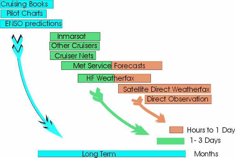
Weather - trying to avoid the bad
stuff - is an all-consuming topic for cruisers. Resources for predicting it
range from long term climate information to direct warnings from satellites
overhead. Pick and area of interest and read on!
The basic rule we use for avoiding trouble is to wait until the weather
is the way we want it for the upcoming passage. Sometimes we want light
winds to ease into a trip, other times we want to leave on the tail of a weather
system that will help us along for a day or so. The corollary to this rule
is that most forecasts are 50-75% accurate for 2-3 days, beyond that they are
unpredictable.
The long term outlook is what we, and most long-distance cruisers, use to
plan where we will be during each season:
- Tropics during the Winter
- Equator or temperate region during the cyclone season
- Move with the trades and seasonal winds.
- Move between tropics and temperate zones during Autumn and Spring.
This outlook is based on climate observations over many years, and on
average, are reasonably accurate. Of course weather does not always behave
like the averages - out of season storms occur or other anomalies may affect this year's cruising, but using this
information for planning where to be each season is the still the best approach.
The cruiser's bible is World Cruising Routes by Jimmy Cornell -
information about it and other sources of long-term weather prediction can be
found on our Books page. For those cruising the
Pacific, the state of El Ni�o is important, and information can be found at the
El Nino
site
All forecasts observe current conditions and use models to predict what will
happen over the next few days. We have learned a few things about the
forecasts and the methods of delivery to the cruiser.
Weather forecasts of interest to most cruisers are produced by
meteorological offices of various countries around the world (there are also a
few private forecasters). Accuracy depends on time and the model used. Our experience shows
something like:
- 24 hour 75% accurate,
- 48 hour 60% accuracy
- 72 hour <50% accuracy
- >72 hours indicative information only
The US, Britain,
and France have the most widely used models. We have been
most impressed
by the French models, particularly when we were in New Caledonia - we compared
their predictions with actual conditions for approximately 15 days in 1998 and
found them very accurate. As
cruisers we have no control over the models used - we get whatever information
is available in the cruising area.
The forecasts produced by the Met services get to the cruisers by many
means. Some of them are:
| Method |
|
Voice Forecasts
- Government and private
- HF and VHF radio
|
| Norfolk, Va, US - NMN |
'Mechanical Mike' voice synthesizer |
| Land-based radio nets for cruisers
(see more details below) |
-HF radio, (Marine or ham bands)
-Run on schedule
-Relay gov't forecasts
|
| Other cruisers |
-HF or VHF radio; ad-hoc
-Relay recent observations |
| Australia |
2201, 4134, 6206, 8176, and 12365 kHz
time-shared by stations around the country:
- Darwin at 0833 and 2233 UTC
- Townsville (tbs)
- Brisbane (tbs)
- Perth (tbs)
- Sydney (tbs)
|
|
HF Weatherfax-
- Government run
- HF radio
- Broadcast on schedule
- Usually cover large areas
- 12 to 48 hour forecasts
|
| Halifax, Canada - CFH |
4271, 6496.4, 10536, 13510 kHz |
| Boston, Mass, US - NMF |
6340.5, 9110, 12750 kHz |
| New Orleans, La, US - NMG |
4317.9, 8503.9, 12789.9 kHz |
| Kodiak, Alaska, US - NOJ |
2052, 4298, 8459 kHz |
| San Francisco, Ca, US - NMC |
4346, 8682, 12730, 17151.2,
22527 kHz |
| Honolulu, Ha, US - KVM70 |
9982.5, 11090, 16135, 23331.5
kHz |
| Australia |
AXI: 2628, 5100, 11030, 13920,
and 20469 kHz
AXM: 5755, 7535, 10555, 15615, 18060 kHz |
| New Zealand |
5867, 9459, 13550, 16340 kHz |
| Other Countries |
To Be Supplied. |
|
|
|
| Text Forecasts
|
| Inmarsat |
-Need $2000 Inmarsat satellite receiver
-6 to 72 hour forecasts
-Focused on area near receiver |
|
| Internet |
|
| Direct - The following
Met Offices have provided useful weather information directly to us on
request: |
| New Zealand |
Auckland (at Boat
Books)
and their HQ in Wellington |
| Australia |
Most major towns -
Darwin was very helpful |
| New Caledonia |
Met service in Noumea provided great long
term forecasts - practice your French. |
| Bermuda |
US Navy |
| American Samoa |
Met office near airport |
| French Polynesia |
Each island has a met
station |
|
There are a number of radio networks around the world where volunteers provide
information or service to cruisers. Usually they are ham operators or
ex-cruisers who operate radio stations on land and perform functions like:
- Track yacht locations
- Relay messages between land stations and yachts
- Relay weather forecasts from Weather Services and other cruisers
The ones with whom we have had experience include:
| Area |
|
| Atlantic |
| Southbound II
|
|
We used Herb all the way
from Norfolk to Venezuela |
|
|
|
|
|
|
|
| Caribbean |
| Southbound II
|
|
See above |
| Caribbean Weather |
1230-1300 UTC on
8104 kHz
1300-1400 UTC on
12362 kHz |
check-in for subscribers
only - details at their Web
site |
|
| Pacific |
| Pacific Maritime Net
|
|
|
| Russell Radio |
0730-0900 on 4445
0830-0915 on 12359
0915-0930 on 12353
1600-1630 on 12353
1630-1645 on 12359
1900-2030 on 4445 |
operated by Des; times
local NZ time; they would like a contribution to track your yacht |
|
0700-0800 on 4417 or 6516
1900-2000 on 4417 or 6516 |
operated by Ritchie; times
local NZ time |
| Taupo Radio |
6224 kHz |
|
| Auckland Radio |
|
operated by John Goater
at |
| Tony's Net |
To Be Supplied. |
|
|
| Australia |
| Townsville Radio
|
0603 & 1603 UTC on
2201, 4426,
6507, 8176,
and 12365 kHz. |
Full info in 100
Magic Miles |
| Brisbane Radio
|
To Be Supplied. |
|
| Darwin Radio |
0203 & 1203 UTC on
2201, 4426,
6507, 8176 kHz.
0433, 0833 & 2233 UTC
same freq. |
Offshore forecasts
Coastal forecasts
Full info in Cruising
Guide to SE Asia. |
| Sydney Radio |
To Be Supplied. |
|
|
| Indian |
|
| Red Sea |
|
| Mediterranean |
|
All of the Sources and Delivery Methods for Intermediate
Forecasts can be used for Short Term Predictions since they are usually based on
current observations. In addition there are a few extra assets for short
term predictions:
- Direct Download Weatherfax - Polar satellites that
circle the earth transmit photographs and infrared imagery as they pass
overhead, and this can be received by special VHF receivers connected to a
laptop. $US1000 to $2000 can buy a system from Xaxero
or OCENS.
- Direct Observation - By noting wind direction and
speed plus cloud formation a reasonable prediction for the next 6 to 12
hours can be made. Use the guidance in

|